# The DVA-ArcGIS Toolbox
Along with ArcGIS Pro (opens new window) (tested with version 3.2.2), the ArcGIS Toolbox provides access to services and methods that support the implementation of various types of supply analysis.
# Download and Integration
Download: The toolbox can be downloaded from the TU Dresden SharePoint (opens new window).
Integration: For integrating the ArcGIS Toolbox into ArcGIS, refer to this official guide (opens new window).
# Enhanced2SFCA
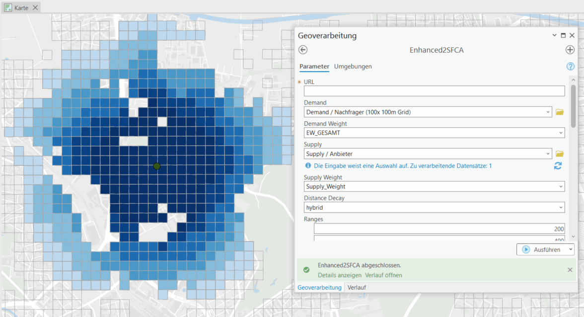
View of the toolbox with a possible result for a catchment area:

# General Usage
Note
This section does not cover methodological basics. For methodological foundations, please refer to the chapter Methods and Technical Details.
The quality of the analysis result depends on the input data. Depending on the technical setup, these can vary widely in supply analysis.
For the calculation of Enhanced2SFCA, the following input data should be provided in the structure outlined below:
Demand Locations or Areas
- Ideally small-scale as point or shapefile feature class (e.g., point feature class with value distributions, municipal boundaries with purchasing power potential, 100x100m census grid with population data)
- It is required to include a demand potential (e.g., population, purchasing power, morbidity) in the attribute table
Supply Locations / Service Providers
- Point feature class
- It is required to include a metric for utilization, availability, or capacity (e.g., number of active doctors at a location, sales area)
Calculation Note
A maximum of 20,000,000 routes can be calculated at the same time.
If the number of routes exceeds this limit, an error message will appear.
Route Calculation:
Number of demand features * Number of supply features = Maximum number of routes (should be ≤ 20,000,000)
# Basic Parameters
# URL
Access to the method server that performs the spatial accessibility calculation. The URL can be obtained from falko.kruegel@tu-dresden.de.
# Demand
Point or shapefile feature class that contains the demand potentials.
Note: A large area and many supply and demand locations may require the calculation of many large catchment areas, which will impact the computation time.
# Demand Weight
Weighting parameter to model demand behavior.
If no demand weight is provided, each feature is considered equal.
# Supply
Point or shapefile feature class containing supply potential.
This is needed for calculating spatial availability.
# Supply Weight
Weighting parameter to model supply potential.
If no weight is specified, each feature is considered equal.
# Distance Decay
Decay types define the importance of distance between supply and demand locations. The following options are available:
- binary - Binary decay $f(d_{ij}) = 1$
- linear - Linear decay $f(d_{ij}) = 1 - \frac{d_{ij}}{d_{max}}$
- exponential - Exponential decay $f(d_{ij}) = e^{-d_{ij} \delta}$
- gaussian - Decay according to the Gaussian normal distribution $f(d_{ij}) = e^{\frac{-d_{ij}^2}{\delta}}$
- inverse-power - Inverse distance decay $f(d_{ij}) = d_{ij}^{-\delta}$
- kernel-density - Density decay $f(d_{ij}) = 0.75 * (1 - (\frac{d_{ij}}{d_{max}})^2)$
- hybrid - Custom decay function
# Advanced Parameters
Further settings for more precise routing:
- Profile: Travel profiles for routing
- Travelmode: Determines whether distance measurement is based on time or distance
- Locationtype: Determines whether routes go from start to target or vice versa
- Avoid Features: Roads to avoid during routing
- Avoid Polygons: Areas to exclude from routing
- Vehicle Type: Determines the type of vehicle used for routing
# Isochrones
Deployment in production mode.
# KNearest
Deployment in production mode.
# Matrix
Deployment in production mode.
# Troubleshooting Error Messages
# ArcGIS Toolbox Enhanced2sfca: URL does not match valid format
URL does not match valid format
Check if the URL was entered correctly. If problems persist, contact falko.kruegel@tu-dresden.de or run the service locally.
# ArcGIS Toolbox Enhanced2sfca: Failed to write results to output
Failed to write results to output
Ensure that the demand data is writable. ArcGIS often uses schema locks.
# ArcGIS Toolbox Enhanced2sfca: Failed to compute travel-time-matrix: Error at location
Failed to compute travel-time-matrix: Error at location
Manual adjustments to location coordinates may be required if locations cannot be uniquely assigned.
# FAQ on Professional Use
# ArcGIS Toolbox Enhanced2sfca: Some Access Values (NULL) Missing
Some Access Values (_NULL_) Missing
NULL values occur when no infrastructure can be reached within the defined catchment area boundaries.